
maptalks 开发GIS地图(42)maptalks.three.35- custom-rgbimage-terrain
开发 地图 Custom GIS 42
2023-09-11 14:21:35 时间
1. 可以说,这是我一直想要的效果之一,
另外一个cesium 和 UE 一起搞得那个。
2. 数据使用的是 ./data/west-lake-area.geojson

3. 扩展类
 1    class Terrain extends maptalks.BaseObject {
 2             constructor(extent, options, material, layer) {
 3                 options = maptalks.Util.extend({}, OPTIONS, options, { layer, extent });
 4                 const { texture, image, altitude, imageHeight, imageWidth, factor, filterIndex } = options;
 5                 if (!image) {
 6                     console.error('not find image');
 7                 }
 8                 if (!(extent instanceof maptalks.Extent)) {
 9                     extent = new maptalks.Extent(extent);
10                 }
11                 const { xmin, ymin, xmax, ymax } = extent;
12                 const coords = [
13                     [xmin, ymin],
14                     [xmin, ymax],
15                     [xmax, ymax],
16                     [xmax, ymin]
17                 ];
18                 let vxmin = Infinity, vymin = Infinity, vxmax = -Infinity, vymax = -Infinity;
19                 coords.forEach(coord => {
20                     const v = layer.coordinateToVector3(coord);
21                     const { x, y } = v;
22                     vxmin = Math.min(x, vxmin);
23                     vymin = Math.min(y, vymin);
24                     vxmax = Math.max(x, vxmax);
25                     vymax = Math.max(y, vymax);
26                 });
27                 const w = Math.abs(vxmax - vxmin), h = Math.abs(vymax - vymin);
28                 const rgbImg = generateImage(image), img = generateImage(texture);
29                 const geometry = new THREE.PlaneBufferGeometry(w, h, imageWidth - 1, imageHeight - 1);
30                 super();
31                 this._initOptions(options);
32                 this._createMesh(geometry, material);
33                 const z = layer.distanceToVector3(altitude, altitude).x;
34                 const v = layer.coordinateToVector3(extent.getCenter(), z);
35                 this.getObject3d().position.copy(v);
36                 material.transparent = true;
37                 if (rgbImg) {
38                     material.opacity = 0;
39                     rgbImg.onload = () => {
40                         const width = imageWidth, height = imageHeight;
41                         const imgdata = getRGBData(rgbImg, width, height);
42                         let idx = 0;
43                         let maxZ = -Infinity;
44                         //rgb to height  https://docs.mapbox.com/help/troubleshooting/access-elevation-data/
45                         for (let i = 0, len = imgdata.length; i < len; i += 4) {
46                             const R = imgdata[i], G = imgdata[i + 1], B = imgdata[i + 2];
47                             const height = -10000 + ((R * 256 * 256 + G * 256 + B) * 0.1);
48                             const z = layer.distanceToVector3(height, height).x * factor;
49                             geometry.attributes.position.array[idx * 3 + 2] = z;
50                             maxZ = Math.max(z, maxZ);
51                             idx++;
52                         }
53                         this.getOptions().maxZ = maxZ;
54                         geometry.attributes.position.needsUpdate = true;
55                         if (filterIndex) {
56                             const _filterIndex = [];
57                             const index = geometry.getIndex().array;
58                             const position = geometry.attributes.position.array;
59                             const z = maxZ / 15;
60                             for (let i = 0, len = index.length; i < len; i += 3) {
61                                 const a = index[i];
62                                 const b = index[i + 1];
63                                 const c = index[i + 2];
64                                 const z1 = position[a * 3 + 2];
65                                 const z2 = position[b * 3 + 2];
66                                 const z3 = position[c * 3 + 2];
67                                 if (z1 > z || z2 > z || z3 > z) {
68                                     _filterIndex.push(a, b, c);
69                                 }
70                             }
71                             geometry.setIndex(new THREE.Uint32BufferAttribute(_filterIndex, 1));
72                         }
73                         if (img) {
74                             textureLoader.load(img.src, (texture) => {
75                                 material.map = texture;
76                                 material.opacity = 1;
77                                 material.needsUpdate = true;
78                                 this.fire('load');
79                             });
80                         } else {
81                             material.opacity = 1;
82                         }
83                     };
84                     rgbImg.onerror = function () {
85                         console.error(`not load ${rgbImg.src}`);
86                     };
87                 }
88             }
89         }
4. 获取数据,并进行数据处理。
 1   fetch('./data/west-lake-area.geojson').then(res => res.json()).then(geojson => {
 2                 const polygons = maptalks.GeoJSON.toGeometry(geojson);
 3                 const polygon = polygons[0];
 4                 let extent = polygon.getExtent();
 5
 6                 const { xmin, ymin, xmax, ymax } = extent;
 7                 let coords = [
 8                     [xmin, ymin],
 9                     [xmin, ymax],
10                     [xmax, ymax],
11                     [xmax, ymin]
12                 ];
13                 let rectangle = new maptalks.Polygon([coords]);
14                 const tiles = cover.tiles(rectangle.toGeoJSON().geometry, {
15                     min_zoom: 12,
16                     max_zoom: 12
17                 });
18                 console.log(tiles);
19                 //buffer
20                 let minx = Infinity, miny = Infinity, maxx = -Infinity, maxy = -Infinity;
21                 tiles.forEach(tile => {
22                     const [x, y, z] = tile;
23                     const { xmin, ymin, xmax, ymax } = baseLayer._getTileLngLatExtent(x, y, z);
24                     minx = Math.min(minx, xmin);
25                     maxx = Math.max(maxx, xmax);
26                     miny = Math.min(miny, ymin);
27                     maxy = Math.max(maxy, ymax);
28                 });
29                 extent = new maptalks.Extent(minx, miny, maxx, maxy);
30                 coords = [
31                     [minx, miny],
32                     [minx, maxy],
33                     [maxx, maxy],
34                     [maxx, miny]
35                 ];
36                 rectangle = new maptalks.Polygon([coords]);
37                 // layer.addGeometry(rectangle);
38                 generateCanvas(tiles, function ({ image, width, height, texture }) {
39                     const terrain = new Terrain(extent, {
40                         texture,
41                         imageWidth: Math.ceil(width / 1),
42                         imageHeight: Math.ceil(height / 1),
43                         image,
44                         factor: 1.5,
45                         filterIndex: true
46                     }, material, threeLayer);
47                     lines.push(terrain);
48                     threeLayer.addMesh(terrain);
49                     animation();
50                     initGui();
51                 });
52             })
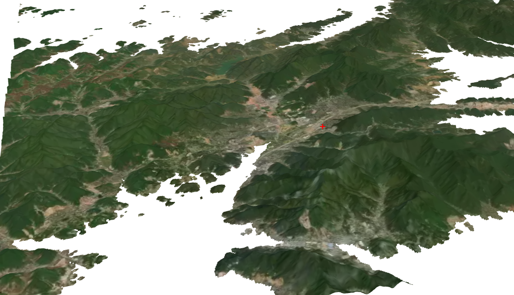
5. 页面显示
6. 源码地址
https://github.com/WhatGIS/maptalkMap/tree/main/threelayer/demo
相关文章
- Java自学指南二、后端开发全景图与快速入门
- 《C++ 开发从入门到精通》——第2章 C++的重要特质分析2.1 什么是面向对象(object-oriented)
- 《Web前端开发精品课——HTML5 Canvas开发详解》——第一部分 Canvas基础
- 《Xcode实战开发》——2.11节组织器窗口
- 《树莓派开发实战(第2版)》——1.10 优化性能
- openlayers4 入门开发系列之地图展示篇(附源码下载)
- 【正点原子FPGA连载】 第二十四章 RTC实时时钟LCD显示实验-摘自【正点原子】领航者ZYNQ之FPGA开发指南_V2.0
- maptalks 开发GIS地图(40)maptalks.three.33- custom-mergedmixin-geometry
- maptalks 开发GIS地图(39)maptalks.three.32- custom-mergedmixin
- maptalks 开发GIS地图(38)maptalks.three.31- custom-linetrip
- maptalks 开发GIS地图(35)maptalks.three.28- custom-grid-height
- maptalks 开发GIS地图(34)maptalks.three.27- custom-grid
- maptalks 开发GIS地图(33)maptalks.three.26- custom-geotiffplan
- maptalks 开发GIS地图(32)maptalks.three.25- custom-flight-path
- maptalks 开发GIS地图(30)maptalks.three.23- custom-electricShield
- maptalks 开发GIS地图(27)maptalks.three.20 - custom-circle
- maptalks 开发GIS地图(22)maptalks.three.15 - custom-animation
- maptalks 开发GIS地图(15)maptalks.three.08 - box
- maptalks 开发GIS地图(11)maptalks.three.04 bar-animation
- maptalks 开发GIS地图(7)maptalks.three.00 介绍
- maptalks 开发GIS地图(6)maptalks 介绍
- maptalks 开发GIS地图(3)maptalks 介绍
- maptalks 开发GIS地图(1)maptalks 介绍